Community Value Mapping in the Northern Green Mountains
In 2009, Cold Hollow to Canada Forest Link Project, the Staying Connected Initiative, and the Vermont Fish and Wildlife Department hosted a gathering which brought together community members from the towns of Enosburgh, Montgomery, and Bakersfield. The goal of this meeting was to compile a multitude of community-value maps created at the event into a single map which depicted areas of high community value overlap. In total there were over 90 community members who attended the event, and each participant was randomly assigned to a group based on a colored dot marker on their meeting agenda. Each of the participants was asked the question: what do you love about living in your town? The participants were encouraged to include many aspects of the town in their responses and were not limited to natural resources elements. Each group was provided with an aerial map of the region which featured roads and contour lines so that they could orient themselves and find town features and landmarks. Participants were given a marker to circle areas they favored, such as the quietness of a certain location, a scenic vista, a good hunting spot, snowmobile trails. Additionally, participants were encouraged to share stories about their favorite places in town and these details were recorded by the group facilitator.
Bakersfield, Enosburg, Montgomery
Citizen Science, Forest Land, Inventory, Land Management, Land Protection, partnerships, wildlife
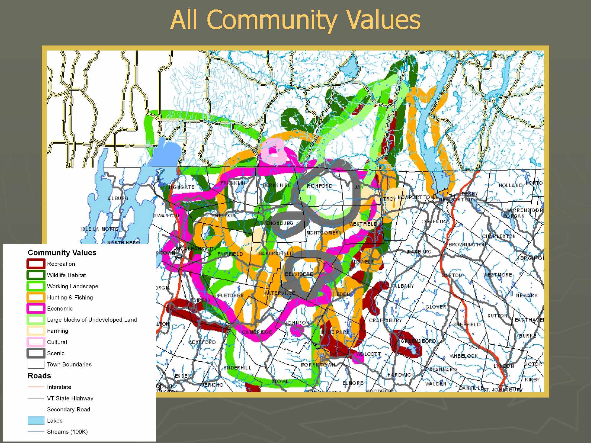
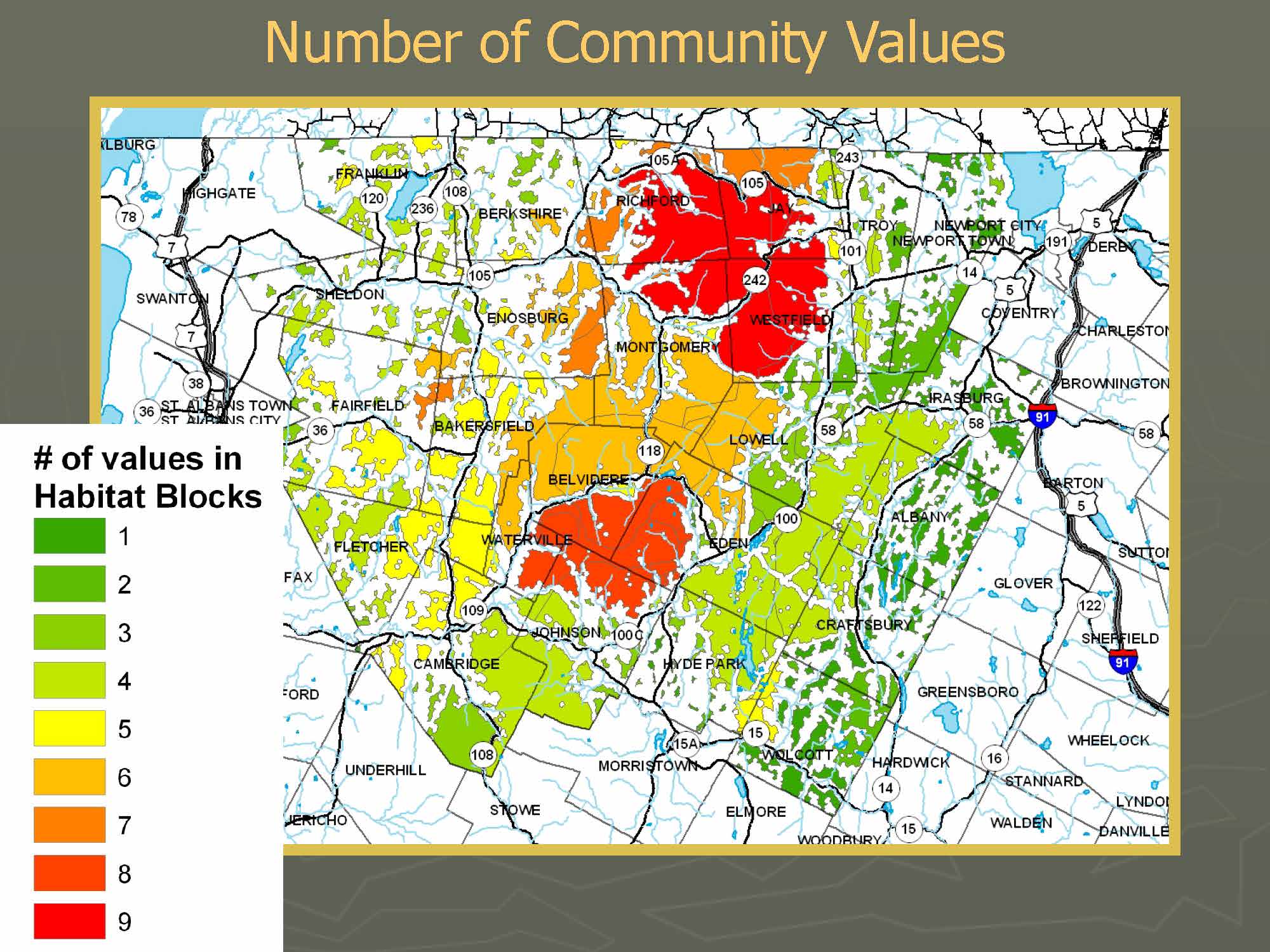
Once each group had finished documenting what each participant loved about their town, each of the groups' maps was collected and compiled into one map. Each note and marking on the map was grouped into broad categories such as places of: hunting value, fishing value, scenic values, cultural values, and wildlife values. The compiled map document highlighted areas of co-occurrence of these values. The resulting map showed that larger forest blocks were largely associated with areas of high community value overlap. These working landscapes provided multiple values, such as hiking trails, historical buildings or landmarks, and cross-country skiing.
These maps will be used by planning commissions to understand locations of conflicting community values and areas of high community importance. This tool is important for understanding underlying values of user groups in these communities and for finding commonalities amongst these parties.
Bakersfield Conservation Commission
Enosburgh Conservation Commission
Montgomery Conservation Commission
Conservation Fund
Staying Connected Initiative
Vermont Fish and Wildlife Department
Wild Lands Network
In order to ensure that the maps were a product of true community values, it was essential that the facilitators of each individual group let the community members dominate both the conversation and contributions to the map. Prior to the meeting, facilitators were given a handbook which outlined their role in the event. The facilitators focused on encouraging: that each participant added to the map, that the marker was passed around to each group member (so each participant had an equal chance of contributing), that the conversation stayed positive and productive, and that participants refrained from commenting on things they didn’t like about the town. The facilitators were members of the local conservation commissions, and having these local faces represented in the event was central to the high public response for this event. The conservation commissions contacted local townspeople who they thought would represent specific interest groups (hunters, fishers, snowmobilers, naturalists), and additionally passed out brochures to recruit any other individuals who may be interested in participating. Getting a sufficient number of citizens together which represented a diversification of interest groups and values was crucial in producing a map that was truly representative of community values of Enosburgh, Bakersfield, and Montgomery citizens.
Representing a true swatch of the population is one of the greatest challenges involved in community value mapping. Getting the word out about this project and recruiting community members which represented various interest groups was difficult. Initially there was some reluctance to contribute to the maps because the community members feared that their favorite places would become the basis of regulations once the map was compiled. This concern was addressed by reassuring that these maps would inform regulation and conservation in a broad sense, and that the information obtained would not be used to prohibit townspeople from using the areas they valued.
Staying Connected Initiative